Video aéreo
Live and 3D from drones and helicopters
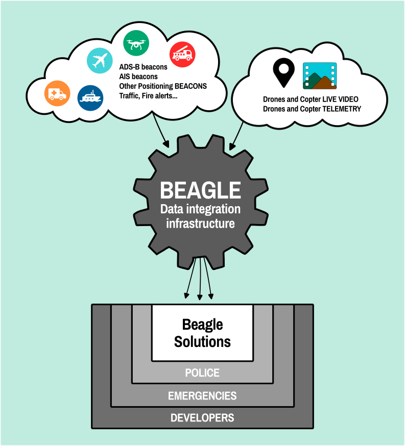
Positions
De todas las unidades desplegadas y más.
Datos
Procesado en tiempo real y automático
API
Fácilmente integrable en otras plataformas
Price
Affordable from 150€/month
from 150€/month
Live and 3D from drones and helicopters
De todas las unidades desplegadas y más.
Procesado en tiempo real y automático
Fácilmente integrable en otras plataformas
Affordable from 150€/month
· Recibe video aéreo y de cámaras fijas, flexibilidad total.
· También recibe posiciones y alertas, operaciones más seguras.
· Procesa y muestra los Data en un mapa, facilitando la coordination.
· Extrae información de las imágenes ofreciendo datos de calidad.
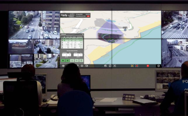
Accesible desde cualquier dispositivo móvil, ordenador portátil o Centro de Mando en pantalla gigante.
Disponible para instalar On Premises o Cloud.
Procesa la información y la muestra en Beagle Map o como piezas de software para integrar en otras apps.
Beagle es fácil de usar e incluso de integrar en otras plataformas.
Using Beagle in EMERGENCIES y SECURITY improves mission coordination and media management.
Beagle is accessible from anywhere with a connection.
As we are developers, we are able to adapt to your own needs. We are always working on new functionalities to improve the effectiveness of the airborne video.
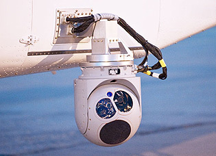
including L3Harris Wescam, FLIR Star SAFIRE, etc)

DJI mini and others
All models and cameras

Stanag 4609 compatible

Públicas o en red privada
Beagle incluye estas herramientas / funcionalidades en la plataforma. Todas son integrables (API) en otras plataformas de gestión ya existentes.

AIS (embarcaciones)
ADS-B (Aeronaves)
LoRa (Long Range)
TETRA (Trans European Trunked Radio)
TetraPol
Contact us for any tecnical or commercial question.
To provide the best experiences, we and our partners use technologies like cookies to store and/or access device information. Consenting to these technologies will allow us and our partners to process personal data such as browsing behavior or unique IDs on this site and show (non-) personalized ads. Not consenting or withdrawing consent, may adversely affect certain features and functions.
Click below to consent to the above or make granular choices. Your choices will be applied to this site only. You can change your settings at any time, including withdrawing your consent, by using the toggles on the Cookie Policy, or by clicking on the manage consent button at the bottom of the screen.